Maptivism: Maps for activism, transparency and engagement
It is estimated as much as 80% of data contains geo-referenced information. So, a lot of information can be displayed through maps. Digital maps allow easy ways to present large amounts of data and reduce complexity. Activists have found creative ways to use maps, but also development organizations have to deal with a lot of spatial information. Using geo-referenced through maps can improve transparency, and yet not so many organizations use it.
**Difference of digital maps ** Digital maps have brought three major changes.
- Digital maps, in contrast to paper maps, can be combined with all kinds of data even in real time.
- Nowadays, everybody can access huge data from the public domain and combine these with maps.
- Citizen maps are created through voluntarily worldwide effort and participation, are freely available and offer new ways for transparency.
The Tactical Tech Collective has a great guide for beginners and comes up with a good description of why maps are so helpful:
“Advocacy organisations worldwide face great challenges. One of these is how best to communicate and disseminate information to communities, staff, founders, governments and other organisations in a world saturated with information, media and advertising. They may also need to keep track of complex and diverse information in their own work.”
By the way, there was also an interesting online forum by New Tactics on 'information activism' with many examples and exciting discussions.
**But why are make maps so different? ** Anders Peders has come up with some simple points in his presentation “Geomapping Making Invisible Data Visible”:
- Recognition: Ooh that’s the place we are talking about!
- A feeling of connection: It’s around the corner!
- Connecting the dots (topics) on complex issues.
- Engagement: This has to change! I want to help out.
**Maps for activism and campaigning ** Maps have a long history and since the early days maps have been used for many purposes, such as to show changes through bygone times and to manipulate them for propaganda. But never before it has been so easy for individuals and groups to use maps for own purposes. The Economist goes a step further and writes “mapping technology has matured into a tool for social justice.”
There are various projects using maps worldwide and here are a few examples:
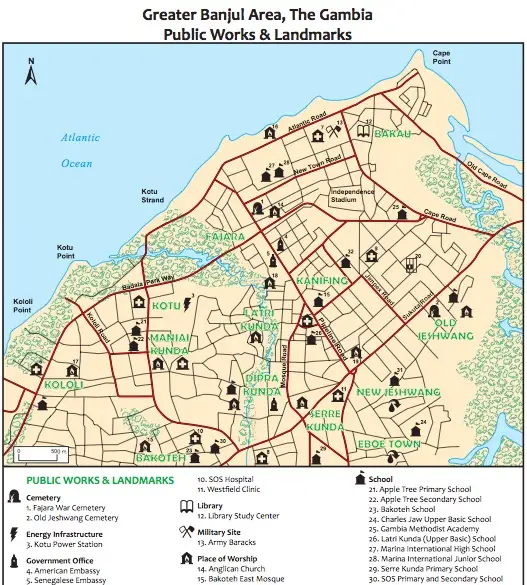
Green Map System has engaged communities worldwide to map green living (nature and cultural resources). In one case, a map was created for the environmental hazards and challenges in the greater Banjul area in Gambia. Other maps from Europe are already interactive.
"Eight Maps" has been mapping people in San Fransisco, who donate for a campaign against a law that supports sex marriage, trying this way to put them on the spot. This example also shows how far such campaign might go into privacy issues.

Another great example comes from Worldmapper:
Ecological footprint of each country in the world
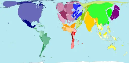
© Copyright 2006 SASI Group (University of Sheffield) and Mark Newman (University of Michigan).
Another nice, albeit printed map series, is an Atlas of Radical Cartography, "a collection of 10 maps and 10 essays about social issues from globalization to garbage; surveillance to extraordinary rendition; statelessness to visibility; deportation to migration.” My favorite map is of the only walking track left in Manhatten, where you are not followed by surveillance cameras.
One key role will be played by the OpenstreetMap project. Other than Google Maps, it offers all geocoded information for free and is, equally to Wikipedia, an open project. I am working these days on a local politics project for transparency. The richness of geodata was astonishing and very helpful. It all started with the city of London and is now a worldwide movement. I went to the annual State of the Map conference in Amsterdam, learnt a lot about mapping and filmed some interviews. It was great to meet finally Mikel Maron, foundation member of OpenStreetMaps, who gives fascinating examples of how open maps benefit people living in informal areas in India.
Watch the Interview with Mikel Maron
Fredy Rivera from Colombia describes the dangerous work of mapping in Colombia and how they plan to provide better geodata to indigenous groups in the rising competition around water resources.
Watch the Interview with Fredy Rivera
Arun Ganesh has done some incredible mapping efforts for the city of Chennai in cooperation with the local administration. He even went a step further and build a great website to find public bus connections and organized the printing of maps to post them on local bus stations.
Watch the video with Arun Ganesh](https://www.youtube.com/watch?v=qTOr6au-j6s)