5 inspiring examples for worldwide Maptivism

Jan / 15 / 2010

“But the maps provided something that the narrative and statistics lacked [...] We could articulate the case in words. [...] But when you’d put up the maps, they’d stop listening to you and look at them [as if to] say, ‘Is this really possible?’” Reed Colfax in an interview by Bob Burtman (water distribution example below)

There are a growing number of cases of Maptivism (Maps + Activism) around the world. I wrote about the great potential for engagement and transparency before. Although it is not a new method, it is certainly still quite different from the old school maps – because of the easiness to use digital maps. There are also more and more tools offered to either get geodata or to use existing data to visualize it more easily. GeoCommons is one such service for open geospatial data.
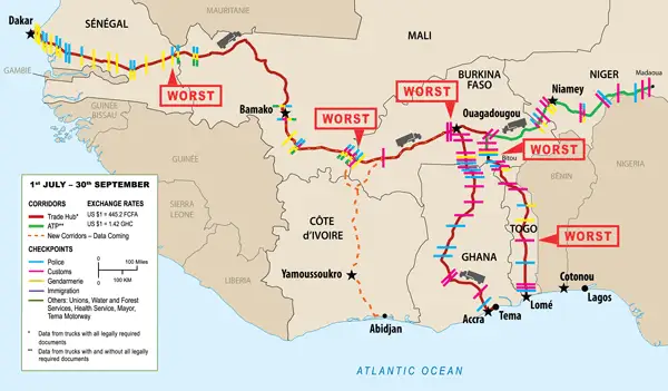
Western Africa

The West Africa Trade Hub, a USAID funded project did an interesting project. They questioned truck drivers in Western Africa about their experiences with checkpoints. The results were long delays and high bribes at region’s worst checkpoints (mapped below). A recent interview I did with Mark Davies indicated also some interesting insights from African trade and the potentials of social networks.

Worst-Barrier-Map

Courtesy of the West Africa Trade Hub project.

China

The China Real Time blog has highlighted an initiative by the Chinese blogger Guo Baofeng for a China Pollution Map:

“The chart (developed on Google Maps) allows viewers to mark spots associated with high levels of pollution or incidents of contamination, based on publicly available information. Since it was open for public participation last week, the number of views has more than doubled to about 5,000 compared to a week earlier, when it was first displayed online.”

Due to the recent move of Google to re-think its engagement in China, hopefully this map will not be censored any time soon.

China Pollution Map

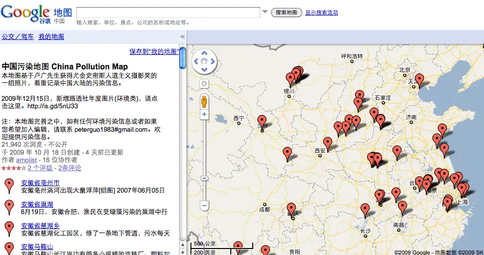
(Hat tip to Giulio Quaggiotto)

USA

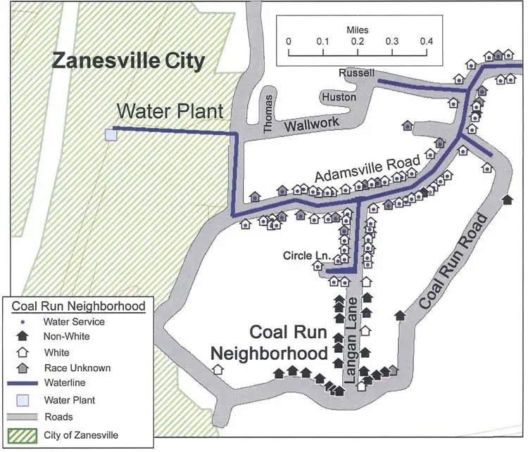
Bob Burtman highlights intriguing mapping work in his article by the Cedar Grove Institute for Sustainable Communities. Through surveys and public available data, they were able to produce the map below, which shows the partial distribution of water in city of Zanesville.  Read the full article about fascinating ways to combine data and mapping.

Zanesville Water Map

Courtesy the Cedar Grove Institute for Sustainable Communities

Brazil

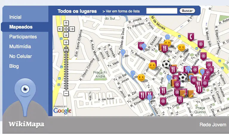
Mapping can be particularly helpful for community development. Corinne Ramey reports form a project to map slums in Brazil through mobile phones. “By uploading information to the phones, the reporters are mapping the unmapped, one road and cafe at a time.” Once places are mapped they can be used for multiple purposes

Courtesy of wikimapa.org.br

Kenya

A similar, but more extensive project has happened in the biggest informal area in Nairobi: Kibera. A team of mappers trained cohabitants of Kibera to map the largest slum in Africa.

Map of Kibera

OpenStreetMap

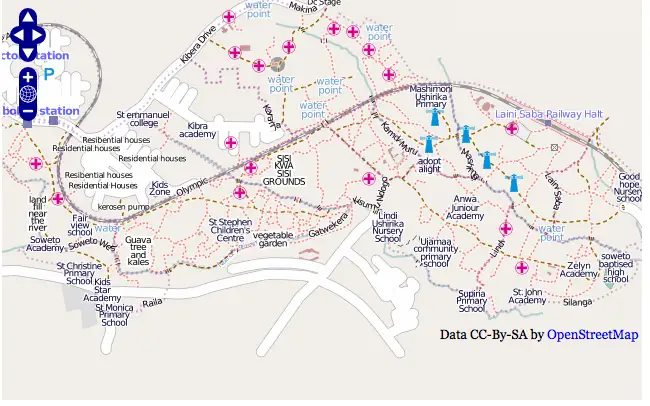
Some of you probably know that I am particularly amazed about the OpenstreetMap project. Often, people ask me why we need such an open map, if we already have Google or Yahoo maps? Because it is not only about maps, but more importantly, about what we map and that we can use the data freely to use it the way it is needed. Or as Mikel Maron nicely puts it:”But the point is that with open source and open data, people everywhere don’t have to wait for Santa Google to gift them with new features ..”

When do you start mapping?

Mapping is really easy. I walk around in Mexico these days, during my free time and map streets and buildings with a GPS enabled mobile phone – a cheap GPS device is enough and costs under 100 Euro. That way you can already participate in tracking streets worldwide and upload them to OpenStreetMaps. Here is more information on how to participate.

Lastly, there is a great initiative by the tactical tech collective called Ten Tactics: “Exploring how rights advocates use information and digital technology to create positive change.”

Popularity: 68% [?]

Related posts:

  1. Context is king – new inspiring ideas on Maptivism If you sit in front a long list of information,...
  2. Maptivism: Maps for activism, transparency and engagement It is estimated as much as 80% of data contains...
  3. Presentation: A journey to the world of Maptivism A while ago I was asked, by Markus Beckedahl, to...
  4. From global to local: Mobile, mapping and action Location, mobile phones and the Internet, combined together, are becoming...
  5. Cairo, Johannesburg, Mumbai – 24 hrs Google Buzz and location-based information pops up everywhere In this blog post, I will dive into the latest...

{ 22 comments… read them below or add one }

Ken Gillgren January 16, 2010 at 11:51 pm

One more particularly timely example, the Ushahidi crisis mapping application with recent contribution to Haiti earthquake recovery (http://www.ushahidi.com/)

ldi January 17, 2010 at 10:19 am
Holger Nauheimer January 18, 2010 at 7:21 am

More examples for Open Mapping: http://bit.ly/6LGoGY

Radical Inclusion January 18, 2010 at 7:21 am

More examples for Open Mapping: http://bit.ly/6LGoGY

Fondapol January 18, 2010 at 8:49 am

Crisscrossed / 5 inspiring examples for worldwide Maptivism http://ff.im/-eseNU

agentska January 18, 2010 at 6:43 pm

RT @SpaceSyntaxGirl: Inspiring examples of worldwide #Maptivism: http://bit.ly/6LGoGY | @BitBoutique @thornet @cle50000 @Ckreutz @urbandata

Laura Staniland January 18, 2010 at 6:53 pm

RT @SpaceSyntaxGirl: Inspiring examples of worldwide #Maptivism: http://bit.ly/6LGoGY | @BitBoutique @thornet @cle50000 @Ckreutz @urbandata

Ken Gillgren January 18, 2010 at 9:40 pm

5 inspiring examples for worldwide Maptivism http://ow.ly/Xe7U also include Ushahidi crisis mapping platform http://ow.ly/Xe8j

Barbera van den Berg January 21, 2010 at 4:10 pm

Great post about 5 inspiring examples for worldwide Maptivism http://bit.ly/6LGoGY

Knowledge for Health January 27, 2010 at 4:06 pm

5 inspiring examples for worldwide Maptivism (maps + activism) http://bit.ly/7kJU6B

cjk January 27, 2010 at 4:17 pm

RT @K4Health: 5 inspiring examples for worldwide Maptivism (maps + activism) http://bit.ly/7kJU6B

itsuro yoshimi January 27, 2010 at 4:18 pm

参加形GISとでもいえるのかは不明だけど期待感あり。学校と自販機など見たいなあRT @K4Health 刺激になる5つの世界中の地図ティビズムの例(地図+活動:Maptivism maps + activism) http://bit.ly/7kJU6B

Michael Cervieri March 4, 2010 at 8:01 pm

RT @avilarenata: 5 inspiring examples for worldwide Maptivism http://bit.ly/6LGoGY

ScribeLabs March 4, 2010 at 8:01 pm

RT @avilarenata: 5 inspiring examples for worldwide Maptivism http://bit.ly/6LGoGY

TubesCodeContent March 4, 2010 at 8:01 pm

RT @avilarenata: 5 inspiring examples for worldwide Maptivism http://bit.ly/6LGoGY

Mike March 5, 2010 at 4:28 pm

Why not tracking streets worldwide and upload them to WIKIMAPA??? ;-)

km4dev March 17, 2010 at 11:24 am

5 inspiring examples for worldwide Maptivism: http://bit.ly/dhh6r4 #km4dev

Afrika Kabissa March 17, 2010 at 1:48 pm

RT @km4dev: 5 inspiring examples for worldwide Maptivism: http://bit.ly/dhh6r4 #km4dev

Gabriel Sarmiento March 27, 2010 at 8:29 am

Muy buena idea mapear las comunas o zonas marginadas http://ow.ly/1rx0J el mejor es el caso de las favelas en Brasil #mappingtheunmapped

Tsuda Shoken, 津田正顕 April 1, 2010 at 10:38 pm

Interesting Maps. RT @gquaggiotto 5 inspiring examples of maps for activism: corruption, pollutions, slums http://bit.ly/6vOtaU

Gabriel Sarmiento April 12, 2010 at 2:00 am

RT @juanmrestrepo: Camino a la inclusión digital @hiperbarrio http://bit.ly/bTPLh8 #proyectos // ojalá esto les sirva http://ow.ly/1rx0J

David Hood April 20, 2010 at 10:22 am

Leave a Comment

{ 2 trackbacks }

Previous post:

Next post: